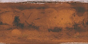
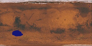
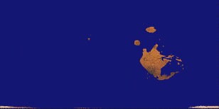
Mars |
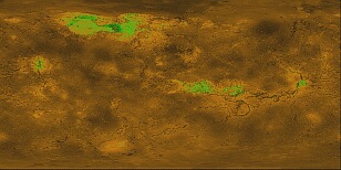
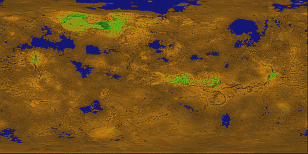
Venus |
 |
 |
 |
 |
 |
 |
 |
 |
 |
 |
Terraforming images
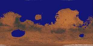
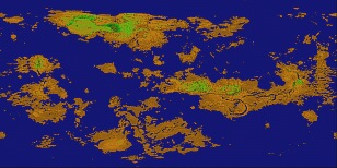
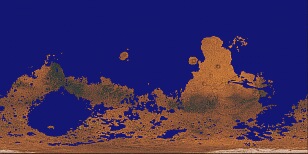
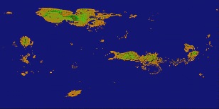
This page displays some results obtained using POV-Ray to simulate the visual effects of terraforming on Mars and Venus. Elevation maps of these planets (obtained from the Web) were used as height-fields in POV-Ray. A "water plane" was then aded to the POV-Ray scene, and its height varied in order to simulate different ocean levels.
This approach is purely pictorial, and makes no attempt to address the scientific or technological problems associated with actually getting such masses of water in place on these planets...
The following table of images shows the results in going from a dry planet to a nearly-oceanic planet. Within POV-Ray, the vertical scaling of both height-fields was the same, and the range of heights of the sea level was similar. Note that some liberties have been taken with the image map used for Venus; it was generated from the elevation map that was used, with a bit of green thrown in for good measure.
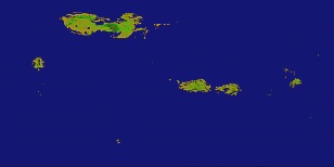
Mars |
Venus |
|
|
|
|
|
|
|
|
|
|
It is to be noted that Mars has rather a southern-hemisphere bias on the distribution of land-masses, whilst Venus has a more even distribution for moderate ocean levels. However, Venus presents a more broken, island-based topography, compared with Mars' somewhat continental appearance.
In the last frame, Olympus Mons, Tharsis Montes, Alba Patera, Sinai Planum, Syria Planum and Solis Planum remain on Mars, and some of Valles Marineris is still visible. On Venus, Ishtar Terra in the north, and Ovda Regio, Thetis Regio and Alta Regio remain near the equator; Beta Regio is to the west at low-northern latitudes.
One of the above images may be wrapped around a sphere to show the three-dimensional appearance of the planet with the given water level. This is shown below, for each planet, with three different longitudes and with a simple simulated atmosphere.
Venus
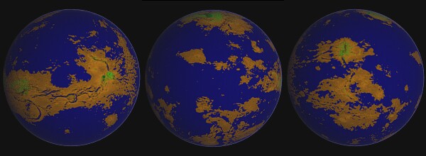
Three views from above the equator.
Left image: Aphrodite Terra lies roughly along the equator, with Thetis Regio (left) and Alta Regio (right) shown as green. The channels of Diana Chasma, Dali Chasma and Artemis Chasma are evident. Meridian approx. 165º.
Middle image: shows Ishtar Terra near the north pole, with Maxwell Montes as a small, dark green patch. Eistla Regio lies south of Ishtar Terra, with Alpha Regio and Lada Terra being the main land masses in the south. Meridian approx.10º.
Right image: shows Beta Regio (green) in the mid-north latitudes, with Devana Chasma running south from it. Phoebe Regio and Themis Regio are equatorial and south, respectively. Meridian approx. 290º.
Mars
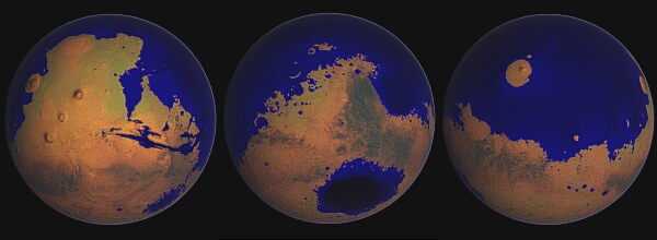
View as per Venus images. For these images, the image map which provides the colour information has been combined with the height-field image. Therefore, the different shades of blue in the oceans, etc., give an indication of the depth of the water. This process also slightly modified the colours of the image map- just a hint of green.
Left image: Olympus Mons to the left (west), the Tharsis Ridge with Arsia Mons, Pavonis Mons and Ascraeus Mons slightly to its east, and Valles Marineris just south of the equator. The lake formed from Argyre Planitia is near the south-eastern limb. Meridian approx. 90º.
Middle image: Syrtis Major is just east of the meridian. The inland sea formed from Hellas Planitia is to the south. Meridian approx. 315º.
Right image: Elysium Mons forms an island in the encircling northern ocean. Meridian approx. 200º.
Refinements to the planetary images